By John Dingell III
If you are going to be hunting in a new area this fall, you can obtain free digital topographic maps offered by the U.S. Geological Survey at their ‘Map Store’ web site. They also sell paper versions which you can have mailed to you
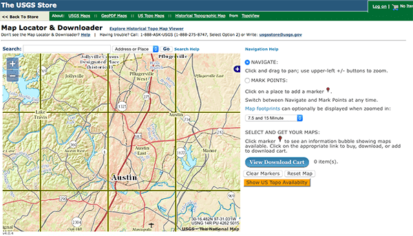
To map your area, you’ll want to blow up the map locator image (using the + button) until the square sections representing the different available topographic map quadrangles appear. Then click on the quadrangle representing the area whose map you want. A red marker will appear and you can click on it to get a bubble which shows what maps are available. Then click on ‘download’ and the specific map will be placed in your ‘download cart’. Then you can click on the blue ‘download cart’ button and the download will begin.
You’ll want a map with a 7.5 minute grid, which will be drawn to a scale of 1:24,000 and usually have 5 foot elevation contour intervals in flat lands like Michigan. This is the USGS’ finest detail standard map. Larger minute grids (15 minute and larger) will lack sufficient detail to get a good feel for the land you will be hunting. The bubble will offer you 7.5 minute grid maps which date back to the 1930’s; even earlier in some quadrangles.
The most detailed maps are usually those from 1945 to 1992. USGS put a lot of time and effort into detailing various features present on the land in that era and most are still there. The maps drawn by USGS since 1993 are more accurate in their description of terrain, but fail to identify a lot of details present in the earlier maps. Post 1992 USGS topographic maps omit details and features such as trails, ruins, mine locations, springs, wells, power transmission lines, telephone lines, railroads, recreational trails, pipelines, survey marks, and buildings. It is no coincidence that Bill Clinton was inaugurated in 1993.
You probably should download two maps of the quadrangle you are interested in. The most current map to get the most precise placement of terrain features and a 1945 – 1992 vintage map to see a lot of the lost features and details. You can do this by placing both maps in your download cart and downloading them together.
These maps are big files, typically running from 10 MB to 40 MB. If you have high speed internet they will download without any problems and you can save them to a file on your computer. They are in .pdf format and take a little time to load in a pdf viewer; especially in older computers. Generally, they are too detailed for viewing in smartphone pdf browsers as they are supplied by USGS, but you can create separate files of small sections and view them on a phone satisfactorily or decontent them in a pdf manipulation program.
If you’re uncomfortable interpreting topographic maps and their symbolism, here are three good web sites which can help you:
http://nyfalls.com/maps/topographic-guide/
https://en.wikipedia.org/wiki/Terrain_cartography
https://en.wikipedia.org/wiki/Topographic_map
If you want the full course on topographic map interpretation, USGS Professional Publication 60 [Salisbury, Rollin D.; Atwood, Wallace Walter; The Interpretation of Topographic Maps; 1908] is still one of the very best learning tools:
http://pubs.usgs.gov/pp/0060/report.pdf
This is a large file (about 60 MB), but it’s 80 pages of well written text and over 150 pages of color plates to illustrate the text. Well worth your time.


Get quadrangles mailed to you. They’re light, cheap, sturdy and don’t have the pitfalls of digital maps such as requiring batteries or having insane load times. USGS, unlike most other .gov agencies, actually gives a crap about customer service too so shipment is fast. Also it lets you stretch your landnav skill muscles a bit so you’re not reliant on tech.
A map and a couple good compasses is all you need. If you want to get all high tech about it get a Garmin E-Trex to supplement your map.
http://www.thetruthaboutguns.com/2016/09/daniel-zimmerman/huting-new-ares-get-fee-topographical-maps-usgs/
How much is the fee?
Digital is free. Last time I bought paper quadrangles it was $7/quadrangle. That was in 2013. The maps are quality enough to take a severe beating from me for years and still be perfectly usable.
If you actually want paper maps you can use to shoot bearings and such these are well worth buying.
That’s not what he asked 🙂 See the headline for enlightenment.
I missed the fee because I was laughing about the “huting”.
These maps are invaluable if you’re going off the beaten path. Be aware that some “trails” may have grown over and disappeared. Regardless, these are still probably the easiest ways to move around the landscape and therefore likely have critters nearby.
Good stuff. And timely. None of my local suppliers have a good map of the Hells Canyon wilderness.
I’m headed there in a little over a month by horseback for an elk/bear/cougar hunt.
I’ll be ordering paper copies as soon as I get home.
Wow. My pellet gun hunt of the morrow kinda pales in comparison.
“I’m headed there in a little over a month by horseback for an elk/bear/cougar hunt.”
Around these parts, the ‘Cougars’ are the ones on the hunt.
(And sometimes, I let them catch me…*wink*)
Driven through plenty of times in my semi over the last 2 years. I’ve got “season” pictures from the mountain pass on 95 south of grangeville. The view of the valley is spectacular snow or green.
If you need the maps quickly you can down load the maps, put them on a thumb drive, and have them printed at a local printing shop or Office Depot. They probably are not as durable but it’s a trade off. I have been teaching myself land navigation and these maps are great.
Buy the ONX Hunt Maps to really get your maps on. Better than any topo because they deliver precise land ownership and boundaries, along with all features-big and small, natural and manmade.
I never leave home with out them.
I think that really depends on where you are.
Those exact maps got a high ranking NM Dept. of Game & Fish official in serious hot water for hunting on private land.
To be fair though, that may be NM specific. No one really knows or posts where some of the boundaries are when it comes to old private property, especially Spanish Land Grants, in NM.
I’ve got Oregon loaded on my phone and my iPad, but I won’t have cell service where I’m going. So it’ll be useless.
I looked at their gps unit and it’s really expensive. Plus the screen is about two inches square. Worthless.
If I wanted to “hunt” in washington D.C., would I need a topo map?
Did Mr Dingell submit this to ttag? Or is that just a clever name?
Mr. Dingel was a representative of the se Michigan community I grew up in- I’ve generally gad a favorable impression- but would be surprised if he was very pro gun at all and downright floored if he read this site, let alone contributed…….
Comments are closed.